(There’ll Be) Peace in the Valley
It’s well before dawn when we arrive at Zabriskie Point. Stars still fill the western sky, above the snow capped Panamint Mountains. Down the hill from the roadside overlook is a short trail that cuts through the chalky, barren ground.
The land in front of us looks like the moon. In technicolor. Multi-colored layers of rock and sand, hardly a plant to be found. It’s an alien looking place, once a lake, now a sinking basin full of salt and dust.
When we arrived there was only one other lone traveler standing around the point, which made it seem even more desolate, but by the time the sun begins to paint its way down the distant ridges of the Panamints, the overlook is chock full of people.
Still, hardly anyone makes a sound, and when they do it’s only the soft footfalls of boots treading the alkaline gravel or hushed whispers that fade in the empty stillness and silence of the desert.

I lived just four hours from Death Valley for twenty-five years. I’ve been all over Europe and Asia, but I never made the trip out here. Until now. Now that I live clear across the country from Death Valley, I finally arrive. Sometimes you miss what’s right in front of you. Sometimes you think you have to go around the world to find the exotic when in fact it’s just down the road.
After the sun is well up and the light on Zabriskie Point has become the even glow of mid-morning we drive down the valley to Badwater, the lowest point in the United States.
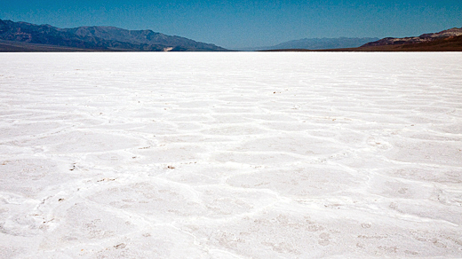
There’s no one around. The desert is utterly silent save the crunching of our boots as we walk out on the salt flats. Even in the morning light the salt is almost blindingly bright, by mid-afternoon it will be painful to look at.

Only one person died to give Death Valley its name. And that was during the winter. Death Valley is also not technically a valley. Valleys have entrances and exits, streams that feed through them. Death Valley is a basin, no entrance, no exit. Whatever little rain falls in Death Valley returns back into the ground, the excess eventually making its way here to Badwater, where it mixes with the salt and slowly sinks into the rock or evaporates off into the air.
Badwater is where Death Valley ends in that respect. It is the exit point, where the basin returns its water back into the earth, taking the land with it — Badwater continues to sink down a little bit every year.
But it’s hard to imagine Death Valley as the lake it once was when you’re standing in the middle of a salt flat feeling parched, salt caked to your shoes and nothing but pure featureless white as far as you can see.
The previous day we drove through Titus Canyon. The drive starts on the eastern side of the park where a four wheel drive trail veers off the main road and cuts straight through the high desert. The flat expanses of desert to the east are carpeted with yellow flowers, the product of a relatively wet (by Death Valley standards) spring.
Eventually the road begins to slowly wind upward, past barren, red rock outcroppings and on toward the appropriately named Red Pass, which crosses the main ridge of the Grapevine Mountains, where the road begins the descent into Titus Canyon proper.
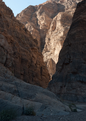
The canyon itself is an impressive display of geology and the power of earthquakes — massive, jagged walls of thrust up strata loom at every side. Looking down the canyon is like staring into the history of the earth.
Black limestone has been thrust up through red and white layers creating a rainbow palate of rock. The dark black rock dates from the Cambrian period when Death Valley was awash in the algae that would later become the limestone that surrounds us.
 The further on we go, heading west back toward Death Valley proper, the narrower the canyon becomes. The rock walls creep closer and closer, eventually squeezing the road and the dry stream bed it has been following into one single track.
We get out and walk around for while. It’s cool here in the narrows, the walls are too steep for the afternoon sun to penetrate. The ranger said there are hanging gardens up on the rock face above us, but the walls here are too steep to see much.
The next day, after watching the sunrise and seeing Badwater, we drove up to Aguereberry Point, midway up in the Panamint mountains. At the end of the road a short trail leads out to the point where the ridge line drops off into the vast basin below.
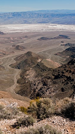
Death Valley is white from above. Slat flats and borax. Once people came here to dig up borax, copper, gold and handful of other metals that have been thrust up from the depths of the earth.
 Pete Aguereberry, for whom the point is named, mined in the area until he died in 1945. But Aguereberry didn’t build the road to get the mines, he built his road to the point simply because he liked the view.
Today the National Park service has built a newer road (still dirt and somewhat rough) but along the way you can still catch glimpses of Aguereberry’s original work snaking its way through the sagebrush.
It must have been a brutal job back when Aguereberry did it. But it is a commanding view, the hills seem to fall away at your feet, offering a glimpse of the land far beyond the basin to the east and up and down it to the north and south.
Far below, running along the opposite side of the salt flats, I can make out the road that will take us down to the south and eventually out of Death Valley.
Later, as the car winds down that same road I stare out the window thinking that I should really go to Savannah, Georgia, a place I have heard about for years, but never, in the ten years I’ve lived in Georgia, have I been. Sometimes you just forget about things that are right there in front of you.
Thoughts?
Please leave a reply:
All comments are moderated, so you won’t see it right away. And please remember Kurt Vonnegut's rule: “god damn it, you’ve got to be kind.” You can use Markdown or HTML to format your comments. The allowed tags are
<b>, <i>, <em>, <strong>, <a>. To create a new paragraph hit return twice.